
GPS coordinates of the starting point: Lat: 35.024020 Lon: 32.333115
GPS coordinates of the ending point: Lat: 35.024020 Lon: 32.333115
Altitude of the starting point: 273m
Altitude of the highest peak: 388m
Altitude of the end peak: 273m
Starting point: Smigies picnic site, 2.5km from Neo Chorio, within the Akamas region.
Length: a) Short route: 2.5km, (b) Long route: 6km
Estimated duration: (a) Short route: 1 hour, (b) Long route: 2 hours
Difficulty rate: 2
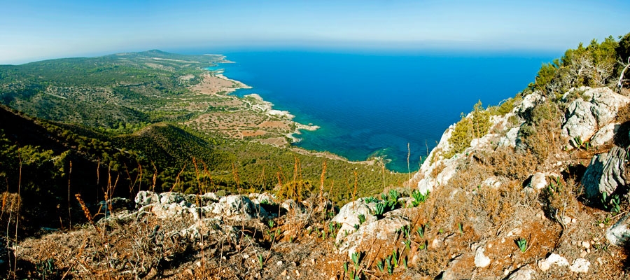
Points of interest: Initially, the trail offers beautiful views of the coastline of the Akamas peninsula to the west including Lara Bay and later on, to the east, with views of Chrysochous bay in the direction of Latsi, Polis, Pachyammos and Pafos forest. The longer route runs past the old mines, magnesium facilities, and abandoned kilns, and through a dense section of the Akamas forest. The trail also connects with the Adonis trail at Kefalovrisia, where you will find a non potable water fountain. At the starting point, the two routes are adjacent to the walking trail of Pissouromoutti. Both routes pass by the Piana fire lookout station of the Forestry Department.
Flora: While hiking you can study the endemic plants: Thyme (Thymus integer), Cyprus germander (Teucrium micropodiodes), Cyprus Golden – Drop (Onosma fruticosa), Entire – Leaved Horehound (Acanthoprasium integrifolium), Sweet Marjoram (Origanum majorana var. tenuifolium).
Fauna: The main species of fauna found in the area are:
Mammals: Fox, hare, hedgehog.
Birds: Wood pigeon, partridge, Cyprus warbler (endemic), Cyprus wheatear (endemic).
The Forest of Akamas serves as a resting point for many migratory birds.
Reptiles: Cyprus viper, Cyprus lizard, Black whip snake.
")
